There are a range of global initiatives to improve the quality and availability of public geospatial data. Millions of volunteers actively work on making these maps as accurate as possible. Examples of these platforms are MapSwipe and OpenStreetMap. MapSwipe focuses on aiding humanitarian projects by helping organizations to be better informed and prepared. OpenStreepMap main focus is being an open-sourced map with User Generated Data which can be used for a wide range of purposes.
In this report, I will review both MapSwipe and OpenStreetMap. First, I will reflect on my engagement with these platforms and examine the importance of such contributions. Followed by a discussion of what I learned from this process and how contributing to these types of communal projects can be incorporated into my daily life.
MapSwipe process and implications;
The first platform I got started on was MapSwipe, available as a mobile application (MapSwipe, 2016). Users can choose between three different tasks to complete: identifying and selecting buildings, comparing satellite imagery to identify changes, and confirming whether buildings have been mapped correctly previously. (figure 1.1)
Before starting any project there is a tutorial to explain how to correctly complete the task. (see figure 1.2) This helped me to contribute to projects with better accuracy and confidence. For the majority of projects, I had to identify and select satellite imagery tiles that showed buildings, and then swipe to the next group of tiles. I did this type of task for the organizations HOT in Sri Lanka, for OSM Papua New Guinea and for Arizona State University. Besides identification tasks, there was one project available which asked to validate existing data for the American Red Cross. (figure 1.3) The assignment was to judge if buildings had been correctly outlined previously. (figure 1.4) As there were no projects available asking to compare satellite imagery, I did not get the opportunity to look into that. Overall, I thought the projects were straightforward, engaging, and meaningful. (figure 1.5)
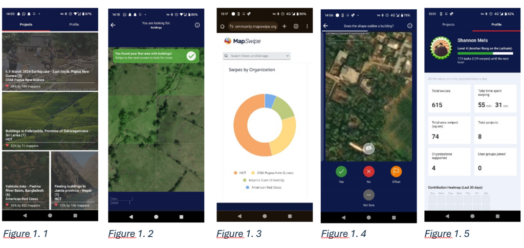
Most of the time MapSwipe provides a direct explanation of the importance of your contributions. When selecting a project, you receive some background information explaining why that particular area requires more accurate mapping. This information did help me to appreciate the projects more and try harder to make accurate contributions. For instance, the project set up by OSM Papua New Guinea helps to map buildings in regions affected by the earthquake that struck there last month. My data and the data of over 236 other participants are combined into a map of the impacted areas. More than 4663 square kilometres have been covered, and this precise local data is of immense help when organizations try to provide humanitarian aid (MapSwipe, 2024).
Just like this one, each project has its own valuable goal. In just the last month over 2100 contributors were able to swipe 1.4 million times in the app. This shows that together with a large community it is possible to help humanitarian aid projects simply from the comfort of our own houses.
OpenStreetMap process and implications;
Secondly, I started my editing journey in OpenStreetMap (OpenStreetMap, 2010), a map of the entire world, with access and edit rights for everyone. To start editing in OpenStreetMap I had to make an account on their online website and follow a quick tutorial explaining where how to edit the map correctly.
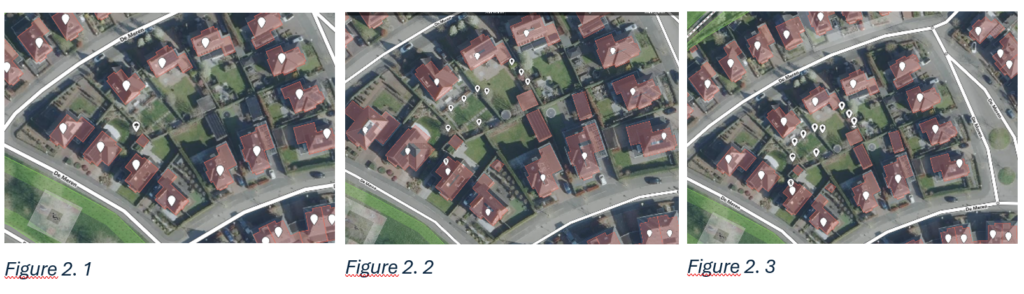
I wanted to edit my neighbourhood in the Netherlands as my first area. Although this location was already thoroughly mapped (figure 2.1), it still seemed like a good spot to start and get comfortable with the editing process. My initial update was to redraw the outlines of some of the houses because they have undergone some modifications over time, such as the addition of a garage or canopy. Furthermore, I was able to add a point for my neighbour’s nursery and areas for my neighbour’s sheds. In the gardens, I was also able to mark trees and trampolines. (figure 2.2)
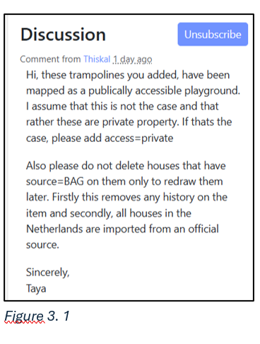
Despite feeling confident in my adaptions, I soon received feedback stating that most Dutch houses cannot be modified like I had tried, as they are imported from an official source. Additionally, I had to mark trampolines as private access to avoid confusion with public playgrounds. (figure 3.1) Learning to incorporate this feedback was probably the most challenging part of editing my neighbourhood. For instance, I had to use the site ‘http://revert.osmz.ru/’ to restore the houses to their initial state. (figure 2.3). This experience showed me that open communication in OpenStreetMap is valuable, as it improves the overall quality of the map and helps beginners acquire the right skill set to edit the map correctly.
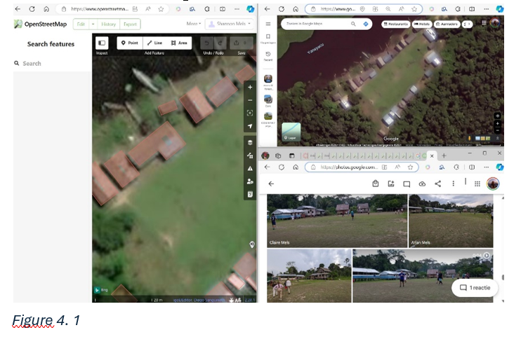
After getting a hang of the editing process I decided to find a place that is more rural and less densely mapped area, so my contributions would be more valuable. Soon I discovered that there were not many such places in Ireland or the Netherlands. Therefore my best guess was to look at Peru, where I travelled to two years back. Even though in the end I did not find an unmapped place I did remember the little village me and my family visited in the Amazone.
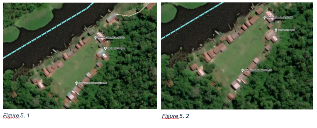
Looking at how it was mapped in OpenStreetMap there was obviously room for improvement. (figure 5.1) Based on the photos I had of the village, the satellite view and Google Maps (figure 4.1), I was able to outline the buildings more accurately and add a few new ones. However, I was unable to add many features, such as functions for certain areas, because I do not remember such details. This limitation did reduce the significance of this contribution. (figure 5.2)
The main objective of OpenStreetMap is to reclaim geographical data as a freely accessible resource since this data is becoming more and more commodified in our capitalist society. OpenStreetMap provides an alternative that is open-sourced, in contrast to commercial maps that limit access and reuse. Founded in 2010, it works similarly to Wikipedia, providing a platform where a community of people can collaborate to create and maintain accurate geographic data. And every little contribution, including mine, helps sustain and improve this initiative. (OpenStreetMap, n.d.-a)
OpenStreetMap’s freely accessible data is used for a variety of reasons. First, it has proven to be valuable in supporting humanitarian aid projects globally. The first time was after the 2010 Haiti earthquake. Volunteers from OpenStreetMap and other non-governmental organizations managed to construct a digital map in just two days, which helped enormously in the recovery process in Haiti. Since then, OpenStreetMap has assisted numerous organizations in providing humanitarian aid after disasters.
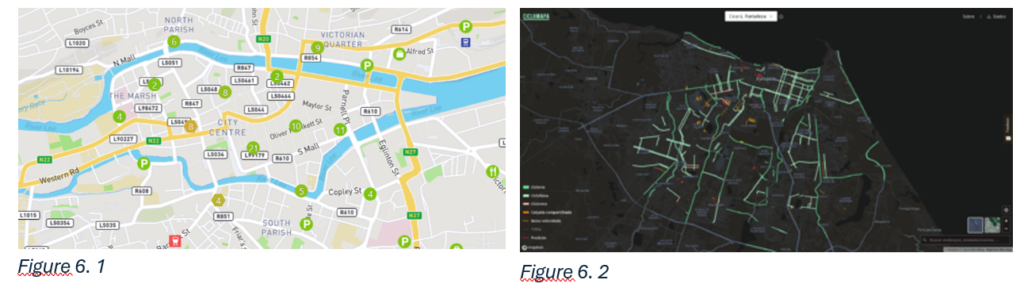
Secondly, several projects use the information available on OpenStreetMap to visualize the data or create new mapping projects. For example, wheelmap, a map which shows which places are wheelchair accessible, uses data provided by OpenStreetMap (Wheelmap, 2010). (figure 6.1) There used to be a weekly ‘Featured Image’ published by OpenStreetMap, highlighting a project that used OpenStreetMap, sadly it was discontinued in 2020. Even though they stopped uploading new images, it still contains a great collection of projects. For example, Ciclomapa is a map with the cycling infrastructure of all cities in Brazil. (figure 6.2) Like these two examples, many other projects rely on OpenStreetMap for its data. (OpenStreetMap, 2020)
Lastly, many companies use the data for a variety of different reasons, the biggest ones include Amazon, Apple, Facebook, Microsoft, Pinterest and Snapchat. Also numerous geodata software and services, transport companies, parts of governments, educational places, media and companies in the humanitarian sector use OpenStreetMap. Some of these companies provide data in return, like Amazon which provides the GPS tracking of their delivery drivers. So even though you were probably unaware of OpenStreetMap’s impact, it is quite significant. (OpenStreetMap, n.b.-b)
Overall OpenStreetMap supports various goals with open-sourced geographical data, from aiding humanitarian projects, to enabling the creation of data visualizations and to assisting companies. Small contributions, like mine, and from other users all over the world make this possible.
Reflection;
Using MapSwipe and OpenStreetMap has allowed me to gain valuable skills and insights. First of all, I discovered the significance of community-driven platforms and initiatives. By examining these platforms, I learned how different people can work together to significantly improve worldwide open-sourced maps and aid in humanitarian help. I never consciously considered that there are other ways to support humanitarian operations besides providing direct assistance on the field or financial donations. But I have now realised that mapping and possibly other kinds of actions can be valuable as well. Additionally, I realized that open-source maps are a great initiative to fight the commercialization of geographic data. In addition to understanding the importance of these projects, I also gained some experience with the technical aspects of mapping. I was able to get a better understanding of how to use mapping tools and interpret satellite imagery. Overall, my experience was educational and inspirational, providing technical skills, insights into community-driven initiatives, and an increased appreciation for open-sourced data and collaborative projects.
Implementation;
After discovering the value of initiatives like MapSwipe and OpenStreetMap it is important to consider how these kinds of projects can be incorporated into my own life. Making sure that I continue to contribute to MapSwipe projects is easy, as I can simply swipe on the app at my own convenience. (Even while doing other activities like watching a movie.) Incorporating OpenStreetMap into my life would mean to update it whenever I discover new important details about a familiar place, explore new rural areas or see the need to improve already existing places. Furthermore, for future projects that have a geographic aspect, I know that I can easily find and use open-sourced data from OpenStreetMap with valuable, free and accurate information.
More broadly, I can commit to looking for and contributing to open-sourced data, both in my free time and in academic research. This would hopefully support several collaborative projects based on user-generated data.
(1690 words)
Sources
- MapSwipe (2016) https://mapswipe.org/en/
- MapSwipe (2024) Buildings in Pallebedda, Province of Sabaragamuwa. https://mapswipe.org/en/projects/-Nvkycj8dZRctuM9LuPg/
- Neis, P. (2024) Unmapped Places of OpenStreetMap. https://resultmaps.neis-one.org/unmapped#2/23.7/3.5
- OpenStreetMap (2010) https://www.openstreetmap.org/#map=5/47.264/-0.264
- OpenStreetMap (2020) Featured Images/ Jan-May 2020 https://wiki.openstreetmap.org/wiki/Featured_images/Jan-May_2020
- OpenStreetMap (n.d.-a) FAQ https://wiki.openstreetmap.org/wiki/FAQ#Why_OpenStreetMap?
- OpenStreetMap (n.d.-b) Who uses OpenStreetMap. https://welcome.openstreetmap.org/about-osm-community/consumers/
- Wheelmap (2010) https://wheelmap.org/search